Back چارسڤيلد ARZ Jaarsveld (lungsod) CEB Jaarsveld German یارسفلد Persian Jaarsveld French Jaarsveld Dutch Ярсвелд Ukrainian جارسویلڈ Urdu Jaersveld ZEA Jaarsveld ZH-MIN-NAN
Jaarsveld | |
|---|---|
Village | |
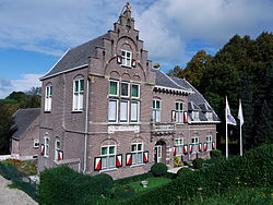
 Polderhuis | |
| Coordinates: 51°58′0″N 4°59′0″E / 51.96667°N 4.98333°E | |
| Country | Netherlands |
| Province | Utrecht |
| Municipality | Lopik |
| Area | |
| • Total | 0.31 km2 (0.12 sq mi) |
| Elevation | 0.8 m (2.6 ft) |
| Population (2021)[1] | |
| • Total | 275 |
| • Density | 890/km2 (2,300/sq mi) |
| Time zone | UTC+1 (CET) |
| • Summer (DST) | UTC+2 (CEST) |
| Postal code | 3413[1] |
Jaarsveld is a village in the Dutch province of Utrecht. It is a part of the municipality of Lopik, and lies about 7 km southwest of IJsselstein.
Jaarsveld used to be a separate municipality, covering a large part of the current municipality of Lopik south of the Lopiker Wetering and Enge IJssel rivers. It merged with the municipality of Lopik in 1943.[3] A large part of the town of Lopik is actually built in the former municipality of Jaarsveld.
- ^ a b c "Kerncijfers wijken en buurten 2021". Central Bureau of Statistics. Retrieved 28 March 2022.
- ^ "Postcodetool for 3413MA". Actueel Hoogtebestand Nederland (in Dutch). Het Waterschapshuis. Archived from the original on 21 September 2013. Retrieved 28 March 2022.
- ^ Cite error: The named reference
plaatswas invoked but never defined (see the help page).

